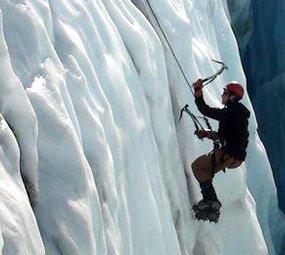
Ice Climbing

Nightfall, MN
The most spectacular natural icefall in Minnesota. Directions: From Grand Marais drive north on Hwy 61 for about 2 miles until you see the bridge over Devil Track River (sign). Drive roughly 100 yards past the bridge and park on the right side of the highway. Make sure you parked well past the last mailbox. Walk back towards the bridge. If the river is frozen follow it into the canyon for about 1 mile. Nightfall flows down the cliff on the left side of the river.
Manitou River, MN
North of Little Marais on Highway 61. Look for the River’s signage on the bridge. Either take the river north (when passable) or follow the north lip of the canyon while avoiding tresspassing on private property. If following the lip, stick to the woods on the north rim until you can hear the Falls. Drop down to edge and walk a bit down river to look for slings on trees on the tops of routes 7 and 8.
Casket Quarry, MN
From Duluth: take I35 to 40th Ave W. Go right on 40th and continue up to the stop sign at 8th Street. Go left (west) to a weird little triangle thing and angle/turn right on Medina. At the top of the hill turn right on 57th Ave W and cross RR tracks. Turn around so you are facing west and park on the RIGHT side of the road ONLY. Walk up the trail to the clearing where you can see the quarry walls. The majority of the routes are to the left on the “West Wall” section of the Quarry.
Sandstone Quarry, MN
From I35, take exit #191. Head East off the ramp, towards the town of Sandstone. Take a right onto Route 123, aka Main Street. Pass the local businesses, including the Ace Hardware. Take a right onto Route 123, aka 3rd Street. Sandstone Quarry will be on your left once you are out of town (not very far – maybe a mile or so from the turn off Main St.).
Minneapolis Ice Climbing, MN
The best access to these formations are the trails that lead down from the city to the shore of the river. The river trail that starts at River Flats Park by the University of MN and then heads south runs past many great areas. Often just a single column or flow, sometimes broad bands or ice most of the routes are short, fairly easy (but can get hard).
The Ice Pit, WI
The Ice Pit is located a few miles west of Green Bay, at 361 Orlando Dr, Hobart, WI 54115. It is open to climbers on weekends and some holidays. Their annual January Demo Weekend (where they teach people how to ice climb) has been cancelled for 2012 – but look for it again in 2013.
Governor Dodge State Park, WI
The park is just three miles north of Dodgeville, WI on Hwy 23. There are two great locations, the Steven’s Falls Area and Cox Hollow Lake. To get to Stevens Falls, go to the Visitor’s Center, grab a map, and head to the area marked Steven’s Falls on the road to Twin Valley Lake. The parking lot is a small pull-off on the right about a mile past the ranger station. Head down the trail east along the river to the falls. To get to Cox Hollow Lake, start from the ranger station and head to the parking lot on the west side of Cox Hollow Lake. Look for the wooden bridge – go across it and head west along the little stream. There is no park trail, but there may be a socially created climber trail.
Wyalusing, WI
It should be noted that much of this Wisconsin ice is not on public land, “Quarry Monster” is a privately owned quarry. You should talk with the locals in the climbing community or read “Superior Ice” for access issues. This area has 6 routes or more with variations and heights of 80-plus feet. Parking is on County Hwy X, north of Wyalusing across the road from the quarry next to a large limestone buttress. This is a great location with over 9 different named climbed surfaces available.
Devil’s Punch Bowl, WI
Located in Menomonie, WI (UW-Stout), the Devil’s Punch Bowl has ice that forms around a sandstone basin. Ice is 20 feet high. Devil’s Punchbowl is just outside Menomonie: Go west on Highway 29 across the Red Cedar River. Turn left onto County P for a couple of hundred yards. Turn left onto Paradise Valley Road for about 1.8 miles. There is a small parking lot on the left side of the road.
Eau Claire, WI
Has climbable ice along the bike path to the south of Devil’s Punchbowl (see above). The depot building/visitor center is along Highway 29 on the west side of Menomonie. The Trail is called the “Red Cedar Trail.” a wide drip 10 to 20 feet tall.
*It should be noted that you should NOT attempt to ice/rock climb without proper instruction from a qualified instructor. To find an instructor, contact outdoor sports shops, climbing gyms, or outdoor recreation groups. You can also avoid having to invest in pricey gear such as crampons, boots, pick axes, and harness before you know if you like the sport or not. Helmets and eye protection are a must for falling ice.


